

Flood Watch, Wind Advisory issued for Redlands as atmospheric river approaches
Flash flooding risk labeled “extreme” as storm nears; sandbags available in Redlands

UPDATE (2:53 p.m. Wednesday, Dec. 24): The National Weather Service issued a Flash Flood Warning for San Bernardino County through 4:30 p.m. Wednesday as thunderstorms continued to produce heavy rain across the region. Forecasters said 2 to 4 inches of rain had already fallen in parts of the warned area, with another 1 to 2 inches possible. The warning cites a threat of life-threatening flash flooding of creeks and streams, urban areas, highways, streets and underpasses.
Locations included in the warning include San Bernardino, Hesperia, Apple Valley, Lake Arrowhead, Crestline, Rimforest and Skyforest, along with portions of Highways 18 and 173. Drivers are urged to avoid flooded roads and follow the guidance: “Turn around, don’t drown.”
REDLANDS, Calif. (Monday, Dec. 22) — A Flood Watch and Wind Advisory will take effect in Redlands and across much of the Inland Empire starting Tuesday afternoon, as a strong storm system is expected to bring heavy rain, gusty winds and an increased risk of flooding.
Storm timing and flood risk
The Flood Watch runs from Tuesday afternoon through Wednesday evening and includes Redlands, surrounding valley communities and nearby mountain and desert areas. Forecasters say periods of heavy rain could cause creeks and rivers to rise quickly and flood low-lying streets and neighborhoods. Areas near recent wildfire burn scars face an added risk of mud and debris flows.
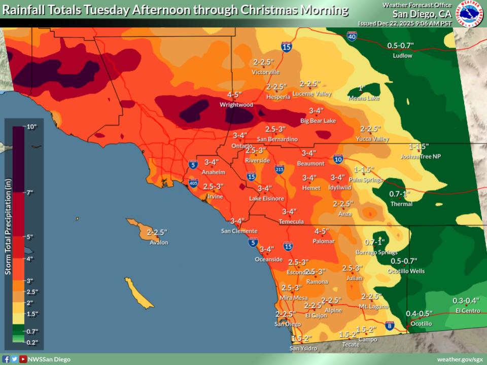
Rain is expected to develop late Tuesday and intensify on Wednesday, with the heaviest rainfall likely from Wednesday morning through the afternoon. Rainfall rates could reach up to an inch per hour at times, with even heavier downpours possible in isolated thunderstorms.
Parts of the Inland Empire, including the San Bernardino area, are forecast to face a “significant” to “extreme” risk of flooding impacts during the peak of the storm on Wednesday.
Wind concerns
Along with heavy rain, a Wind Advisory will be in effect from 3 a.m. to 10 p.m. Wednesday. South winds of 15 to 25 mph are expected in Redlands, with gusts up to 40 mph, especially during the morning and early afternoon hours.
Strong winds could knock down tree limbs, blow around unsecured items and cause isolated power outages. Drivers, particularly those in high-profile vehicles, are urged to use caution.
Local preparedness
To help residents prepare, the city of Redlands is offering free sandbags. Empty sandbags are available at all city fire stations, and a self-serve sandbag fill station is open at the city’s Corporate Yard (1270 W. Park Ave), with sand and shovels provided at no cost.
Redlands sandbag locations include:
- Fire Station 261: 525 E. Citrus Ave.
- Fire Station 262: 1690 Garden St.
- Fire Station 263: 10 W. Pennsylvania St.
- Fire Station 264: 1270 W. Park Ave.
Residents are encouraged to monitor weather updates, avoid driving through flooded roads and take steps now to protect their property. Those living near creeks, drainage channels or burn scar areas should be prepared to act quickly if conditions worsen.
County flood safety information available here.
Originally published 12/22/25
