The 30x30 Challenge: Private land with public interest
A look at how local conservation is key in reaching the nation’s land preservation goals and how a recent struggle between the public interest in private land played out in Redlands.
A look at how local conservation is key in reaching the nation’s land preservation goals and how a recent struggle between the public interest in private land played out in Redlands.
REDLANDS, Calif. – It is estimated half of Earth’s species will be lost by the end of the century. In light of the climate change crisis and the extreme loss of global biodiversity in recent years, there has been a shift in the approach to land conservation. Once focused mainly on protecting large swaths of land to save endangered species, the new paradigm involves identifying land to be managed for conservation to preserve the most species.
According to the Half-Earth Project, the use of new technology and mapping has allowed scientists to identify land where the most number of species can be protected. By weaving protected land throughout communities, people and nature build resilience to climate change and the opportunity for carbon storage to help reduce the effects of greenhouse gases.
First proposed by E.O. Wilson, the half-earth project aims to set aside 50% of the earth for natural habitats to prevent mass extinction. The goal has been adopted by nations around the world to preserve 30% of the Earth’s land and water by 2030 (30x30). The United States adopted the target in 2021. It’s called America the Beautiful.
Here’s the struggle - right now about 12% of land in the United States is protected and more than 60% of the land is privately owned. This makes partnerships with private landowners vital to the success of future land preservation and the protection of biodiversity.
The interest of the public in private land was at the forefront of a recent city Planning Commission meeting. Dozens of residents spoke to halt a planned development in Live Oak Canyon. Residents were focused on the environmental impacts due to climate change and the potential of native cultural resources. On the other side, the developer explained how the landowner had already forfeited development on 80% of the original piece of land.
In this newsletter, we’re looking at the 17-year history of the Mistratta Canyon Tract development and why the Planning Commission voted to stall the development. Plus how maps and a focus on local habitats create a path for communities to participate in 30x30 and protect local biodiversity.
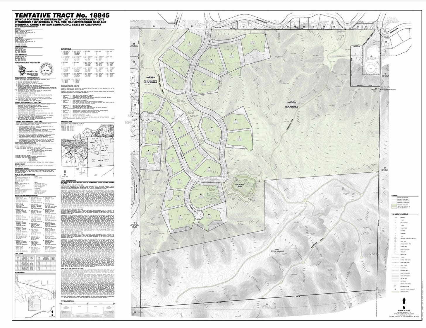
The “Mistratta Canyon Tract”
“I spent hours every week in this area, in this very tract, and I had no idea this was privately owned. I thought it was part of the nature preserve,” a Redlands resident told the Planning Commission last month about an area south of Highview Drive and east of South Lane in Redlands.
The resident was joined by dozens of others pleading with the City’s planning commission to spare the land in North Live Oak Canyon from the Mistratta Canyon Tract development.
Residents shared concerns about the impact on local biodiversity, as well as protecting possible native cultural resources in the area.
Back story: The city council approved the original development in 2005 for 85 residential lots on 180 acres. After a lawsuit brought by Redlands Residents for Rural Living and the subsequent ballot Measure R, the development was whittled back to 36 lots.
In 2014, the City of Redlands spent roughly $1.6 million to purchase 60 acres and the development rights to 12 lots to keep as open space. The developer was left with about 120 acres for development.
The landowner then set aside an additional 80 acres for open space.
Between the revised development plans and the 140 acres planned to be managed by the Redlands Conservancy, the tract plan shows a cluster of 24 lots on about 40 acres of land.
Tentative track map south side of Highview Drive and east of South Lane, Redlands. Source: Redlands Planning Commission Agenda 1/24/23
Before the Planning Commission on Jan 24 was a question of whether to renew the tentative tract plan (originally approved in 2015) before it expired the following day, Jan 25. Without a renewal, the project would have to recreate the tract plan with a new Environmental Impact Review (EIR).
Planning Commission Recap
City staff spoke before the planning commission to recommend the tract be extended and addressed concerns residents brought to the commission at the Jan 10 meeting. One of the main concerns was the limited scope of the 2005 EIR.
According to the California Environmental Quality Act (CEQA) an EIR is valid unless there is proof of a “substantial change” in the environment, project scope, or new information that was not known and could not have been known at the time of the original EIR. This was outlined in detail in the staff report.
According to the city staff, they found no evidence of substantial change in existing conditions or in the environment around the project site, and no new information of ‘substantial importance’ has been presented, thereby negating the need for a new EIR.
A representative of the applicant requested the project be allowed to move forward and reminded the commission that of the original approximate 180 acres, nearly 80 percent have been transferred to the Redlands Conservancy or set aside as permanent open space. Speaking before the Commission he said, “This is the longest project I have ever worked on,” and recalled how the landowner’s stewardship of the property has been commended by the Planning Commission in the past. He expressed the property owner’s interest in being able to get some economic benefit from the developable remnant of the property.
During the public hearing, residents and tribal representatives urged the Commission to deny the tract map extensions. The concerns centered around the 2005 EIR that does not consider climate change impacts over the last nearly 20 years and lacks a complete evaluation of tribal cultural resources.
Tribal Culture Resources
New information that would require a new EIR would be “substantial evidence” of the presence of tribal cultural resources on or around the new development. When the 2005 EIR was completed, there was no requirement to engage in official tribal consultation over the potential impact of tribal cultural resources. The current project and EIR were not legally bound by the new law. City staff said they reached out to tribal representatives via email and received some general concerns but nothing specific that would be cause for a new EIR.
However, representatives from three different Native American tribes expressed concern over possible cultural resources in the development area.
Laura Chatterton, a cultural resource specialist for the Morongo Band of Mission Indians, said they might not be getting the whole story. Chatterton told the commission that because the tribes are not in formal consultation with the city, confidential information regarding cultural resources cannot be shared.
“We’re trying to tell you that we have concerns, we want to give you a little bit more information but the city needs to initiate formal consultation with the tribes in order for us to share that information,” Chatterton told the Commission.
Joseph Ontiveros, Tribal Historic Preservation Officer with the Cultural Resource Department from the Soboba Band of Luiseno Indians, also spoke during the public hearing and requested the city open a formal discussion so they can share substantive confidential information.
A representative from the San Manuel Band of Mission Indians brought the same concerns.
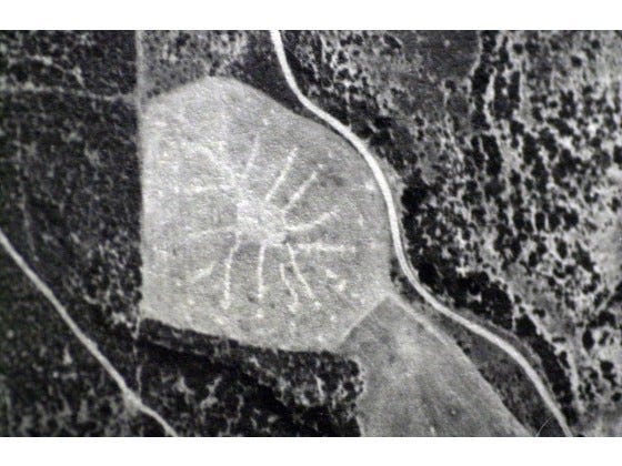
Members of Save Live Oak Canyon spoke about a reputed Native American geoglyph in the area. While there is no evidence of the existence of the artifact except a photo taken in the 1930s, there is a significant solar alignment from the suspected location.
Aerial photo of Little Live Oak Canyon showing what may be a Native American geoglyph. Source: SaveLiveOakCanyon.org
Climate Change Considerations
Residents urged the Commission to consider a new EIR because of substantive changes in the climate crisis since 2005.
Climate change and species concerns: Residents warned about the development’s potential impact on drainage, erosion, and protected plants and trees in the area. In addition, concerns over damage to the natural habitats and the presence of a wildlife corridor were raised. In a letter to the Commission, Sherli Leonard, Executive Director of the Redlands Conservancy, explained that a wildlife corridor has been identified in the area of the proposed development, between Live Oak Canyon Road and Alta Vista Drive. Due to the recent closure of a recognized wildlife corridor in Calimesa, this is the only remaining north-to-south wild corridor between the San Jacinto Mountains and San Bernardino Mountains. “Permitting any kind of development on that recognized wildlife corridor will shut off wildlife movement,” Leonard wrote.
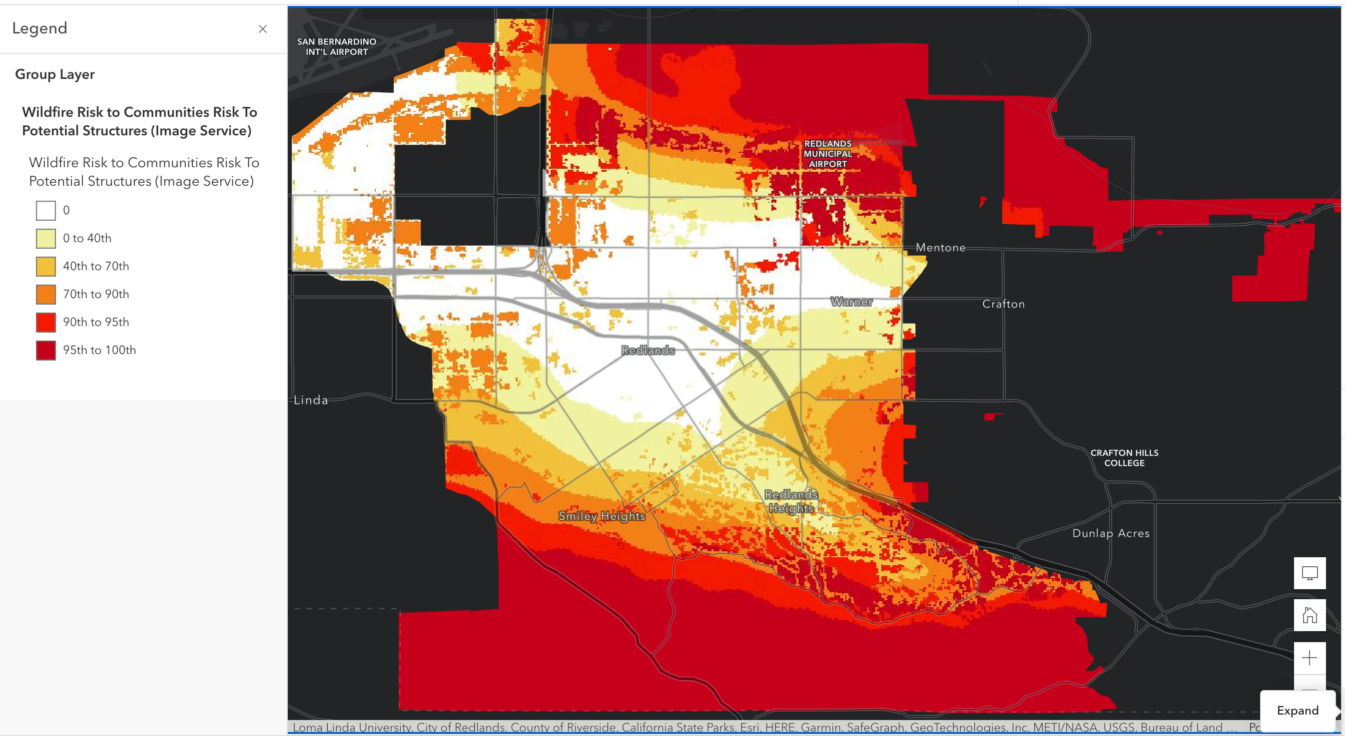
Potential wildfire risks: Residents raised concerns over the increased risk of wildfires due to climate change. The staff report shows the area is known to have a high fire risk and fire protection and landscaping plans are required for the entire project. However, residents contended an EIR from 2005 could not have addressed current wildfire risks.
This 2021 map from the US Forest Service “Risk to Potential Structures (RPS) for the United States” shows the high risk to potential structures in North and South Redlands.
Wildfire Risk to Communities: Risk to Potential Structures in Redlands, CA Source: US Forest Service, ESRI Living Atlas
Zooming into the area of the proposed development shows risk to potential structures in the 95th - 100th percentile.
Wildfire Risk to Communities: Risk to Potential Structures Redlands, CA Source: US Forest Service, ESRI Living Atlas
Increased traffic concerns were also raised by residents who say traffic in their neighborhoods has already increased in the last 17 years.
The Vote
The Commission was advised to decide based on evidence that was presented or what is lacking, but not on speculation. The Commissioners acknowledged the challenge of weighing the private landowner’s interest with the public’s desire to protect this land from development and the need for a full evaluation of tribal cultural resources.
The Planning Commission voted 4-3 denying the time extension for the Mistretta track map.
A resolution memorializing the rationale for the decision will be brought to the February 14 Planning Commission meeting. The reasons listed in Resolution 1612 for requiring a new EIR including:
Substantial evidence of significant changes in biological resources, traffic, and wildfire impacts since the 2005 EIR; and
More than one environmental impact needs to be analyzed under current CEQA regulations (e.g., tribal cultural resources, greenhouse gases) to ensure sufficient mitigation measures for the project.
According to city staff, the applicant has already submitted an appeal. It is expected to go before City Council on March 7.
The 30x30 Challenge and the role of private land owners
Land Preservation for Climate Change Resilience
The risk of extreme heat, drought, and wildfires are predicted to continue to rise over the next century. According to data from Climate Mapping for Resilience and Adaptation, Redlands will have 78-85 days above 100°F by mid-century.
That's about a month more than the current climate.
The CMRA data also calculates the heightened risk of wildfire and drought over the next 20 years.
Land preservation is vital to helping nature and communities adapt to a changing climate and reduce the effects of greenhouse gases.
Right now, California has a goal to preserve 30% of the state’s land and water by 2030.
About 24% of that goal is accounted for with current land protections.
In order to preserve biodiversity and build climate resilience, land protection goals need to be applied across habitats. Setting aside large swaths of deserts or forests won’t be enough. According to conservationists, protecting biodiversity happens across a range of ecosystems. The role of local communities is critical to weaving protected lands together to allow humans and nature to co-exist.
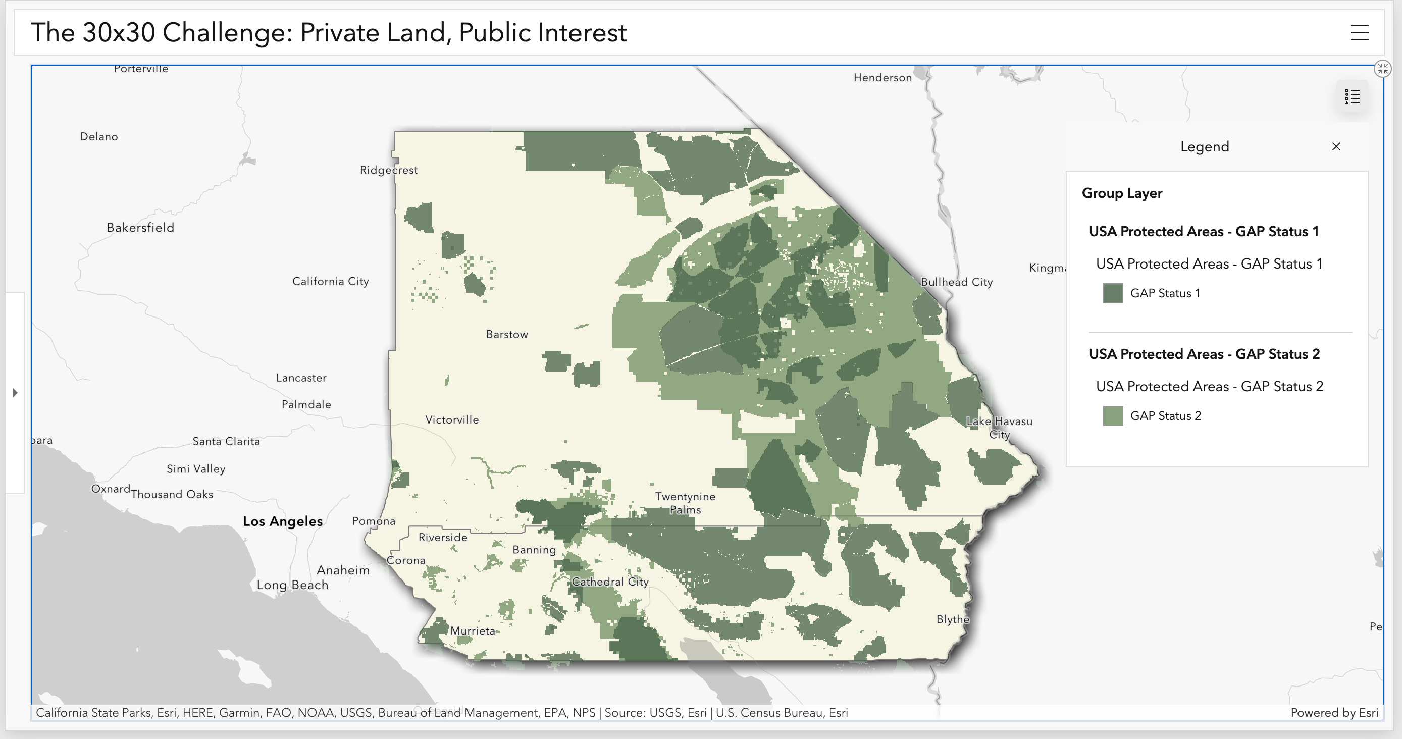
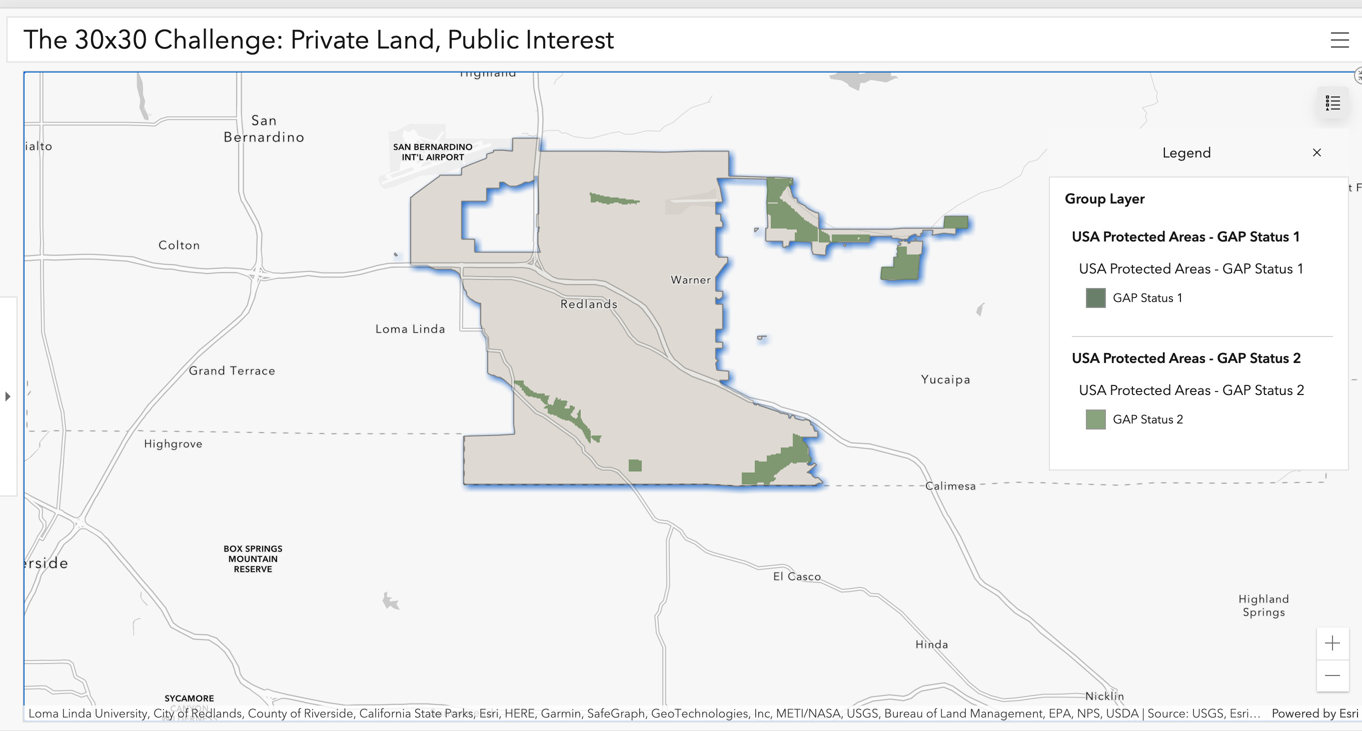
Right now, protected land in California disproportionately covers forests and deserts. As is the case in San Bernardino and Riverside counties.
Protected areas in San Bernardino and Riverside counties. Source: Protected Areas Database of the United States, ESRI Living Atlas
30% Protection Across Habitats
According to The Nature Conservancy, most habitats can reach the 30% goal through increased protection on public land. Other habitats, like grasslands, need support from private landowners. Current estimates show that at least 1.5 million acres of mostly grassland and hardwood woodland across California need some form of private land conservation to meet a 30% target.
Conservation in Redlands
Redlands has made strides in conserving land, led primarily by the Redlands Conservancy. Here’s a closer look at the protected land in Redlands that counts towards the 30x30 state-wide goal.
There are three main areas of conservation in Redlands that protect nature corridors and habitats critical to endangered and threatened species.
Herngt ‘Aki’ Preserve in Live Oak Canyon: The Redlands Conservancy works to protect habitats and oak groves on more than 345 acres that have been set aside for permanent conservation.
The San Timoteo Nature Sanctuary: One of the few remaining habitat wildlife corridors with a shady creek area in the Inland Empire, this nature sanctuary includes 200 acres of conserved land and open access to nature.
Upper Santa Ana River Wash: The Habitat Conservation Plan encompasses about 120 acres managed for biodiversity. The two-decade-long conservation effort includes a total of 1,600 acres of native natural habitat to protect rare, threatened, and endangered species, such as the San Bernardino Kangaroo Rat and Santa Ana River woollystar.
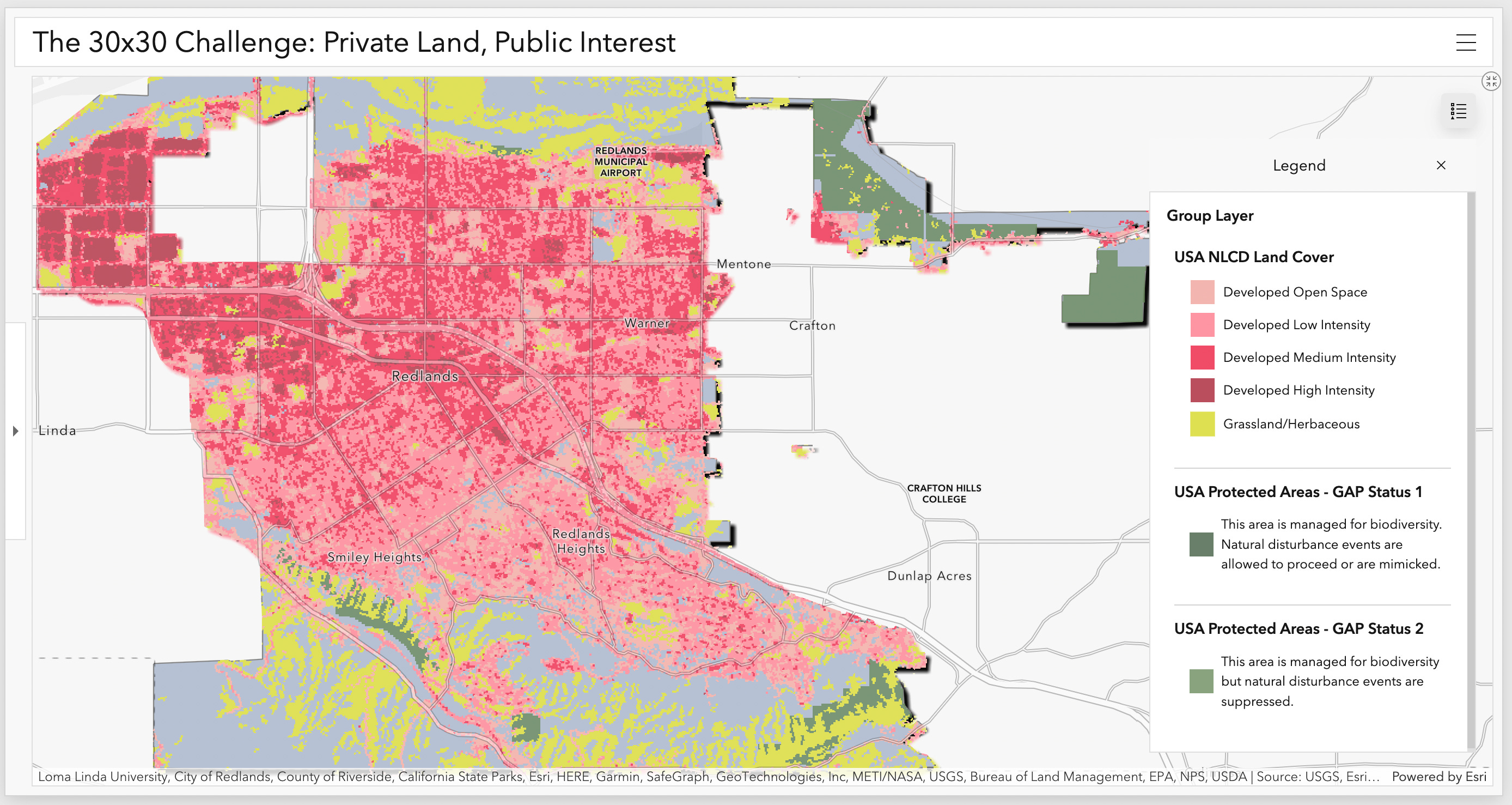
There is an opportunity for private landowners in Redlands to contribute to the grassland preservation goal. This map shows grassland habitats (in yellow) both in North and South Redlands with development (in red) overlapping and encroaching on much of it:
Protected areas of Redlands with grassland and developed land cover in Redlands, CA Source: NLCD and ESRI Living Atlas
Moving Forward: Public and Private Solutions
The Mistratta family worked with the Redlands Conservancy and the City of Redlands on their plans to set aside about 80 percent of their property for open space. I spoke with the Executive Director of the Redlands Conservancy, Sherli Leonard, about the process of private land conservation and what’s next for Live Oak Canyon.
Leonard said at this point, the land won’t transfer to the Conservancy because it was dependent on the development going through. For now, it remains an open space and Leonard says she’s okay with that.
She also told me there is a minor wildlife corridor called Yucipa Creek that goes to Alta Vista through the area of the proposed development. A wildlife corridor could impact a new EIR.
“We need more open space, not more development,” said Leonard, and donating private land comes with a lot of benefits to landowners.
Donating land to the conservancy or creating a conservation easement is a great opportunity for landowners who want to protect part or all of their land from development and take advantage of significant income and property tax incentives.
Others might choose to put their land into a conservation easement to lower the property value and allow their family to inherit the land without having to pay a higher estate tax.
Additional preservation in South Redlands would require partnerships with private landowners, as all land in Live Oak Canyon, not currently preserved, is privately owned.
According to Leonard, the city has about $1.8 million remaining designated for open space acquisition.
Leonard said “the City of Redlands has done a remarkable job in preserving open spaces,” and that the conservancy is always open to accepting the management of more land.
You can read more about land conservation easements here.
If you’re like me and don’t have acres of open natural land to donate…
There are still ways to protect biodiversity in our community.
Measure T Oversight Committee opening
There is an open seat on the Mearue T Oversight Committee for a resident living in City Council District 3. The Committee provides an independent review of the proposed expenditure of revenues generated by the City's transactions and use tax.
The committee’s responsibilities include:
review of the City's expenditure of revenues received from the one percent transactions and use tax imposed by Measure T, on an annual basis;
act in an advisory capacity to the City Council in all other policy matters pertaining to Measure T funds; and
present an annual written report to the City Council.
Residents interested in applying for a non-paid position on this committee may request application forms from the Office of the City Manager, City Hall, 35 Cajon St., Suite 200, by phone at (909) 798-7510 or on the City’s website at www.cityofredlands.org/current-openings
Apply by Feb. 14.
Building climate-resilient neighborhoods
Learn to grow your own food.
The Accelerated Neighborhood Climate Action (ANCA) Redlands is hosting a monthly resilient living workshop, Growing Food In A Changing Climate.
Learn how our current food system affects the climate and reasons to grow your own food. Members from the Sustainable University of Redlands Farm (SURF) and Master Gardeners will teach how to grow plants and food sustainably.
Wednesday, February 15th 6pm Redlands Community Center
Later in the month, ANCA is helping residents learn to make their own worm composting bin. For $20 attendees can build and take home their own bin (minus the worms)! Or come and watch for free.
Saturday, February 25th from 10am – 12pm. SURF Garden Registration is limited to 50
A former broadcast news producer, Stephanie launched CFR in 2023. Originally from Michigan, she’s made Redlands home with her husband and three kids. When she’s not reporting, she’s problem-solving at the climbing gym or trying new local restaurants.