Trucks pass through the intersection of California Street and Orange Tree Lane. Redlands will soon update its truck route map consentrating routes to north west Redlands. (Photo by Stephanie Hastings-Miranda, CFR)
REDLANDS, Calif. — Some Redlands residents may soon see less truck traffic in their neighborhoods. The city is proposing an updated truck route map that removes many long-established neighborhood routes while adding new connections tied to industrial development.
Why it matters: Cities in California’s designated “warehouse concentration region” — including Redlands and much of the Inland Empire — are required to update their truck route maps by Jan. 1, 2026, under Assembly Bill 98. The law requires cities to consider roadway safety, infrastructure capacity and proximity to “sensitive receptors,” including homes, schools and parks.
Jurisdictions that fail to comply may face fines of up to $50,000 every six months, according to state law. The proposed map will go before the Redlands City Council on Tuesday, with a public hearing on Resolution No. 8739.
How the map was developed
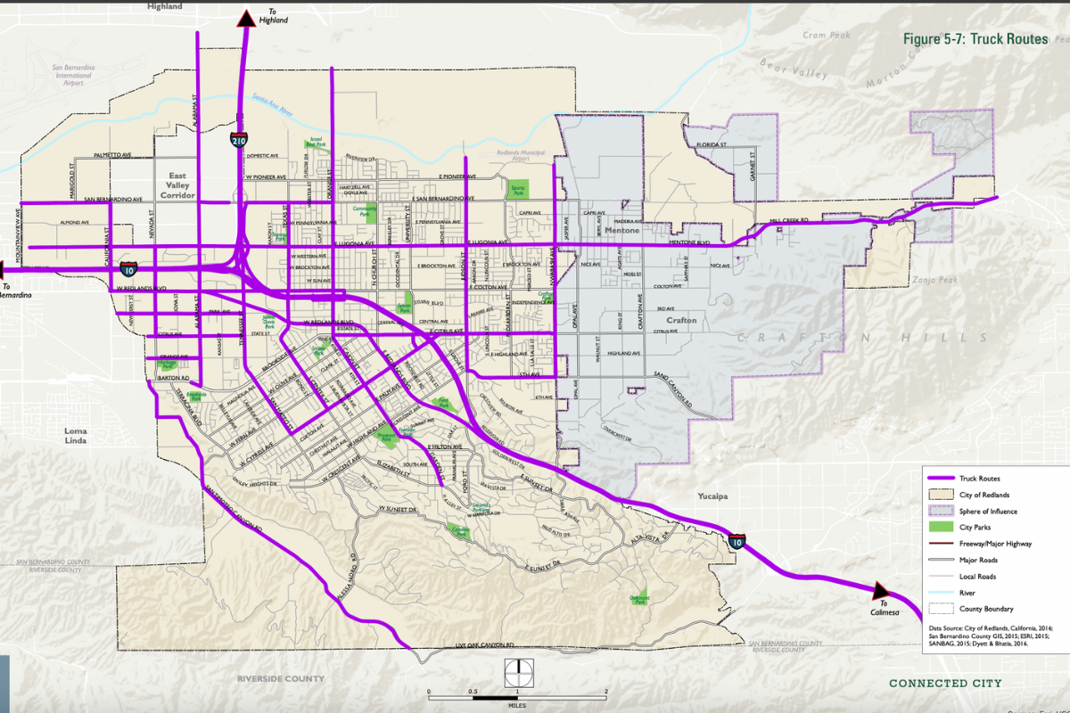
Redlands’ current truck route map was adopted as part of the city’s 2035 General Plan. The updated map is intended to bring the city into compliance with AB 98, which was signed into law Sept. 29, 2024.
The Redlands Traffic and Parking Commission reviewed a draft version of the map in September 2025 and supported removing several routes through residential neighborhoods and downtown, including streets near Redlands High School and San Timoteo Canyon Road.
City staff conducted public outreach in November, including two online community workshops. Attendance was limited, with nine participants at the first meeting and two at the second. No changes to the proposed routes were requested during the workshops, according to the agenda's staff report.
City staff emphasized that AB 98 primarily applies to tractor-trailers serving large logistics warehouses, not local deliveries, construction vehicles, public utilities or other exempt truck traffic already addressed in the municipal code.
What would change if the map is adopted
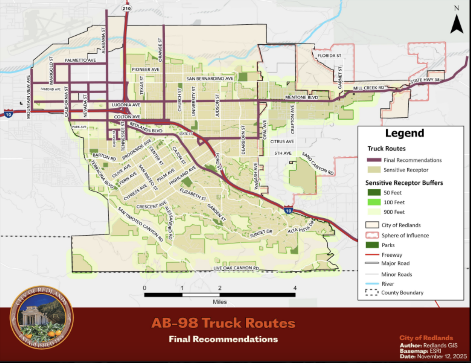
South Redlands neighborhoods: Under the current map, trucks are allowed on several residential streets, including Cajon Street, San Mateo Street, Center Street and San Timoteo Canyon Road. The proposed map removes nearly all truck access from south Redlands neighborhoods, leaving only major arterials such as Redlands Boulevard and west Colton Avenue.
The proposal also adds Kansas Street between W. State Street and Park Avenue as a new designated truck route. City documents identify the change as necessary to serve the recently approved Prologis warehouse development on Tennessee Street and to reroute truck traffic away from State Street.
While AB 98’s formal definition of sensitive receptors focuses on uses such as residences, schools and parks, the proposed Kansas Street truck route would intersect the Orange Blossom Trail, a Class I bicycle and pedestrian corridor which trucks turning out of the warehouse would immediately cross.
Northeast and central Redlands neighborhoods: Several existing truck routes would be removed, including portions of Judson Street and 5th Avenue. Lugonia Avenue and Orange Street would serve as the primary routes connecting industrial areas to regional freeways.
Northwest Redlands and freeway corridors: Truck traffic would be largely concentrated north of Interstate 10 and west of State Route 210, where industrial and commercial uses are already clustered.
2025 Proposed Truck Route Map
The proposed truck route map that will be considered by Redlands City Council on Dec. 16. (Map provided in meeting agenda)
Current Truck Route Map
Redlands current truck route map (above) was created as part of the 2035 General Plan. An updated map will be considered on Dec. 16.
Regional context
Other cities required to update truck route maps under AB 98 include Chino, Colton, Fontana, Jurupa Valley, Moreno Valley, Ontario, Perris, Rancho Cucamonga, Rialto, Riverside and San Bernardino, as well as Riverside and San Bernardino counties.
San Bernardino County is also revising truck routes in unincorporated areas, including the “donut hole” area in northwest Redlands, to better align with city boundaries and regional circulation.
City Council meeting
The Redlands City Council is scheduled to review and vote on the proposed truck route map on Tuesday, Dec. 16.
The full meeting agenda and a preview of the meeting are available online. Public comment may be provided in person or via Zoom.
A former local TV news producer, Stephanie launched CFR in 2023. Originally from Michigan, she’s made Redlands home with her husband and three kids. When she’s not reporting, she’s problem-solving at the climbing gym or trying new local restaurants.