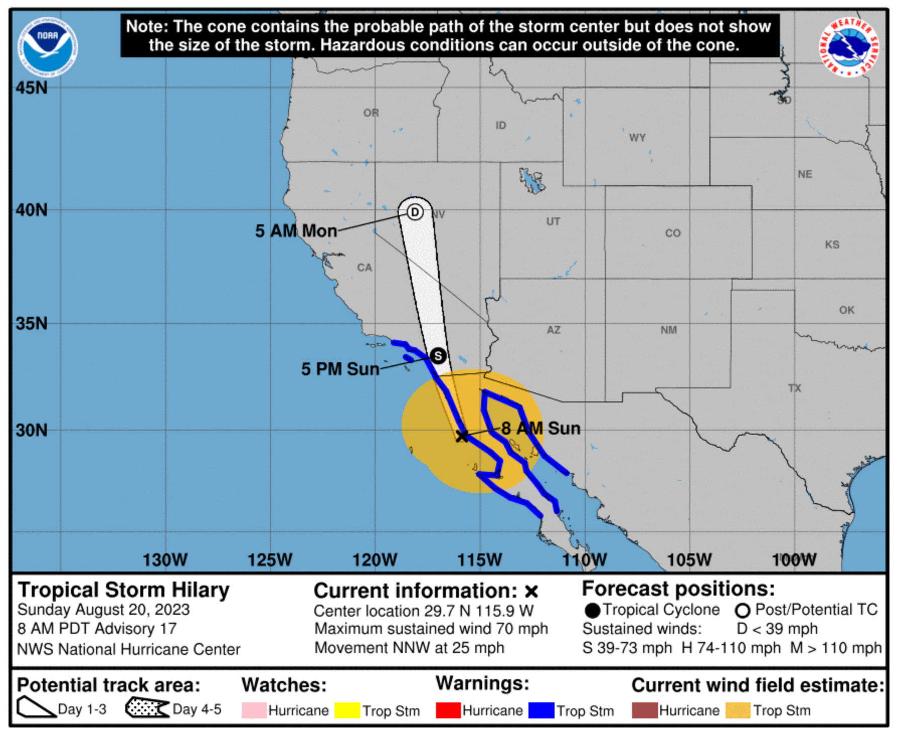
Path of Tropical Storm Hilary updated Sunday, August 20 at 8 AM PT. Source: US National Hurricane Center
7:00 pm: Redlands Unified School District announces school closure for Monday, Aug 21, due to extreme weather conditions from Tropical Storm Hilary. The closure includes all schools, school support sites, and after-school programs. Classes are scheduled to resume Aug 22 until future notice.
8/20 10:30am Update: Redlands remains under a Tropical Storm Warning and Flood Watch. According to the National Weather Service 8:30 am advisory, the region remains at risk of a “potentially historic amount of rainfall.” Here's what to know:
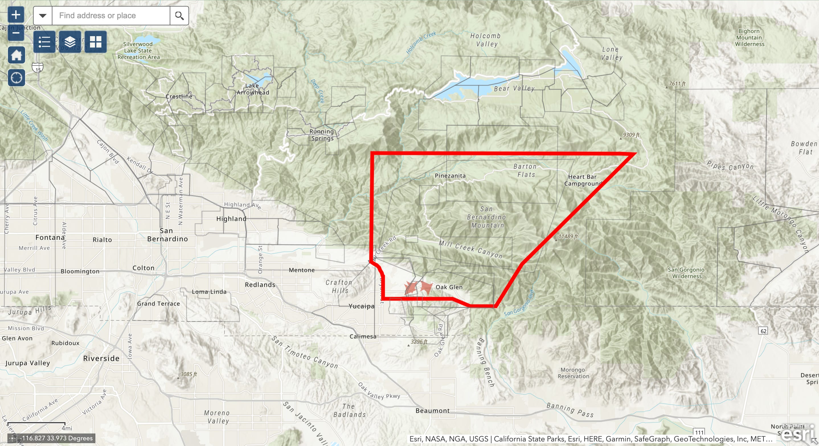
San Bernardino County Sheriff has issued an evacuation order for the communities of Oak Glen, Forest Falls, Mountain Home Village, Angelus Oaks, and NE Yucaipa. Follow the latest updates through the county emergency alert system TENS.
Residents under evacuation order can seek shelter and services at the American Red Cross evacuation center at Redlands East Valley High School, 31000 E Colton Ave, Redlands. Learn more at redcross.org/shelters.
Evacuation area issued by San Bernardino County Sheriff. Click to interact. Source: San Bernardino County Sheriff
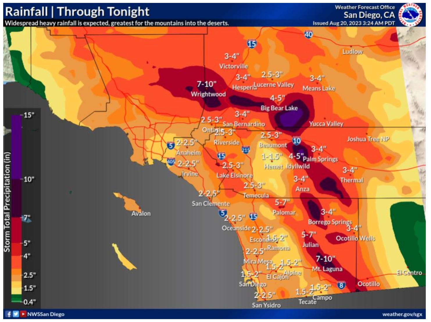
Peak rainfall is expected this afternoon through early Monday morning.
The National Weather Service warns that flash flooding can be expected across the whole region, with rare and dangerous flooding expected across the mountains and deserts.
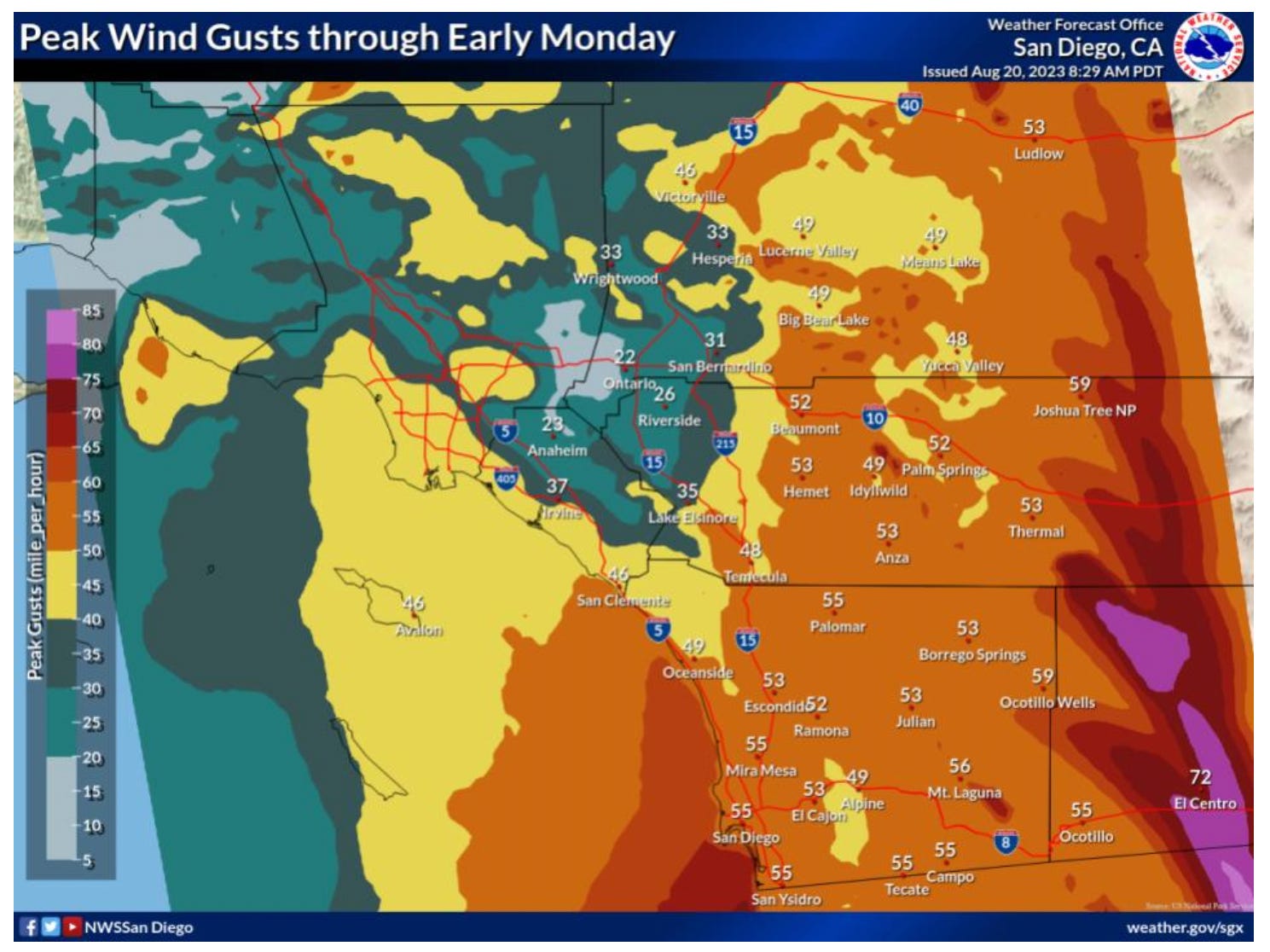
Strong, tropical storm-force winds are also expected today.
Updated maps from the National Weather Service as of Aug 20 at 8:30 am:
Wind speeds up to 50mph are possible in Redlands. Source: National Weather Service, San Diego, CAHeavy rainfall is expected through Sunday night. Source: National Weather Service, San Diego
Update 8/19: Redlands faces threat of flooding, strong winds as Hurricane Hilary moves North
Redlands is under a Flood Watch from the National Weather Service from late Saturday, August 19, until Sunday night. Southern California remains under a Tropical Storm Warning.
On Saturday, the US National Hurricane Center warned of "catastrophic and life-threatening flooding" in Southern California. The potential flood warning stretches across the region, with the risk of rare and dangerous flooding possible in the mountains and deserts.
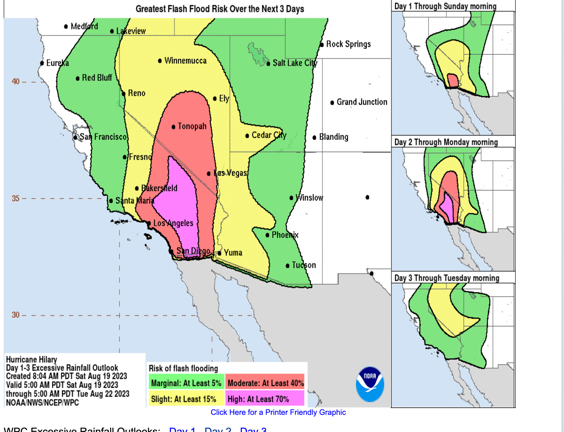
Redlands is in the path of "extreme risk" for excessive rainfall, which can lead to flash floods. Peak rainfall could be 3-4 inches from Saturday night to Monday morning, with 10+ inches in the mountains and desert areas. The forecast warns that events could occur in areas that don't normally flood.
Flash food risk from Saturday 8/19 through Tuesday 8/22. Source: National Weather Service San Diego Office.
“Two to three inches of rainfall in Southern California is unheard of” for this time of year, Kristen Corbosiero, a University at Albany atmospheric scientist specializing in Pacific hurricanes, told the Associated Press. “That’s a whole summer and fall amount of rain coming in probably 6 to 12 hours.”
In a written statement released on August 17, the City of Redlands said it prepares for heavy rains by “regularly inspecting, repairing and cleaning the storm drain system and trimming trees along heavily traveled roads.” The City warns that significant rainfall can still overwhelm the system and cause flooding on roads and in the Zanja and San Timoteo Canyon area.
Residents can pick up sandbags from Redlands fire stations and Fill the bags with sand from the City Yard at 1270 W. Park Ave (shoves provided)
Station 261 – 525 E. Citrus
Station 262 – 1690 Garden
Station 263 – 10 W. Pennsylvania
Station 264 – 1270 W. Park Avenue
Strong winds expected
The peak wind forecast is 35-45 mph with gusts of up to 60 mph from Sunday morning until Monday morning. Officials recommend securing outdoor furniture and garbage cans and maintaining a two-week food and water supply.
On Saturday, San Bernardino County Sheriff issued an evacuation warning for the neighboring communities of Oak Glen, Forest Falls, Mountain Home Village, Angelus Oaks, and NE Yucaipa.
As Hurricane Hilary builds strength off the coast of Mexico, the City of Redlands wants to help residents and businesses prepare for heavy rain and strong winds expected over the weekend.
As of Friday morning, Hurricane Hilary was a Category 4 storm, reaching wind speeds of up to 140 mph. It is shaping up to be the first direct hit of a Topical Storm in Southern California since 1939.
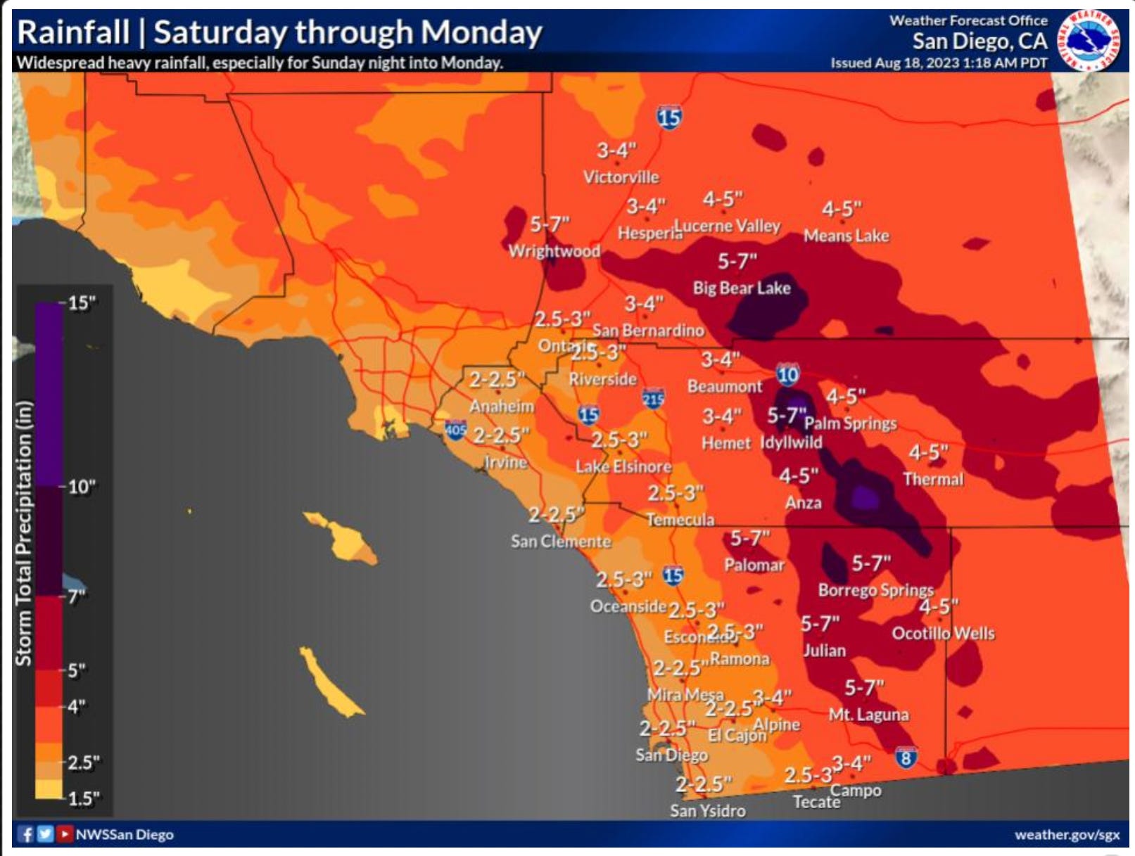
The National Weather Service has issued warnings for the possibility of flash flooding in the Inland Empire from Sunday through Monday. The storm is expected to bring anywhere from 2 to 10+ inches of rain in some areas. The hurricane center says flooding in some areas could “lead to significant and rare impacts.”
Rain forecast as of August 18 at 1:18 AM PT from the National Weather Service, San Diego
Local storm preparation
The City of Redlands offers free sandbags for residents and businesses to help flood prevention efforts.
Here's what you need to know:
Each household or business within the City limits is eligible for up to 10 empty sandbags
Pick up bags from city fire stations:
Station 261 – 525 E. Citrus
Station 262 – 1690 Garden
Station 263 – 10 W. Pennsylvania
Station 264 – 1270 W. Park Avenue
Fill the bags with sand from the City Yard at 1270 W. Park Ave (shoves provided)
Bring identification to show you or your business reside in the City's jurisdiction.
The City of Big Bear Lake is also offering residents free sandbags. Mountain areas could receive 10+ inches of rain Sunday through Monday.
The City of Redlands’ Emergency Operations Division also suggests several precautions residents can take to prepare for the storm, including:
Clearing Rain Gutters and Drains: Ensure that rain gutters and drains are free of debris to prevent water buildup around homes.
Turn off irrigation systems: Prevent further saturation in already wet areas. Adherence to City irrigation restrictions, which prohibit landscaping watering within 48 hours of rainfall, is crucial.
"Turn Around, Don't Drown®": Never attempt to drive through flooded roadways. Remember that just six inches of water can lead to loss of vehicle control, and as little as one foot can float many vehicles.
The City's Facilities and Community Services Department is available for reporting non-emergency flood-related issues at (909) 798-7655.
🍼 Childcare Crisis Hits Home for Redlands Families - Check out our most recent deep dive into the crisis facing families in Redlands as they look to find and pay for child care. This week Senator Elizabeth Warren and Senator Tina Smith wrote this opinion piece about what's being called the child care cliff.
🛣 Funding for roadside encampments - Read about the $4.5M State grant awarded to the City of Redlands from the California Interagency Council on Homelessness (Cal ICH) to help people living in roadside encampments along freeways and highways in the area.
A former broadcast news producer, Stephanie launched CFR in 2023. Originally from Michigan, she’s made Redlands home with her husband and three kids. When she’s not reporting, she’s problem-solving at the climbing gym or trying new local restaurants.