Events
Smiley Library to host Library Days 2026 in Smiley Park
The free, family-friendly event includes food, games, music and outdoor fun for kids and adults.
The free, family-friendly event includes food, games, music and outdoor fun for kids and adults.
The victim was hospitalized with non-life-threatening injuries.
Non-U.S. citizens lose access to SBA funding for small businesses, which provide the bulk of new jobs in California.
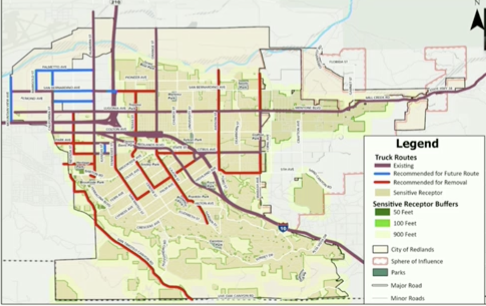
Changes required under a new state law remove truck routes from residential streets while adding new corridors in northwest Redlands, including a Kansas Street segment tied to a warehouse development agreement.


REDLANDS, Calif. — The Redlands City Council unanimously approved an updated truck route map Tuesday night, removing several routes from residential neighborhoods and shifting regional logistics traffic toward commercial and industrial corridors to comply with a new state law.
Why it matters: The changes are required under Assembly Bill 98, a 2024 law aimed at reducing the impacts of heavy truck traffic associated with large-scale warehouse and logistics operations.
AB 98 applies to cities designated as part of a “warehouse concentration region,” a category that includes Redlands and several surrounding jurisdictions. The law requires affected cities to update their truck route maps by Jan. 1 and to prioritize minimizing truck exposure near sensitive receptors such as schools, hospitals and residential neighborhoods.
Details of the new routes: City planning officials said the revised map removes truck routes that currently pass through residential areas in both North and South Redlands and adds routes primarily in northwest Redlands, where industrial and commercial uses are concentrated.
The updated criteria represent a shift from traditional truck route planning, which focused primarily on roadway capacity and truck weight limits, explained Planning Manager Brian Foote.
Foote said the updated criteria reflect a shift toward minimizing truck exposure near sensitive receptors.
“The criteria changed in terms of now sensitive receptors and avoiding or minimizing exposure to sensitive receptors from passing trucks,” Foote said.
The law requires cities to consider roadway safety, infrastructure capacity and proximity to “sensitive receptors,” including homes, schools and parks. It also encourages cities to maximize the use of freeways, highways and major arterial roads and to engage the community during the update process.
City staff conducted outreach to neighboring cities and San Bernardino County to ensure route alignment across jurisdictional boundaries, Foote said. Staff also contacted tribal governments, Redlands Unified School District and local utilities and held two community meetings in October. The draft map was reviewed by the Traffic and Parking Commission, which provided feedback that resulted in additional revisions.
Concerns raised by city council: During council discussion, Councilmember Denise Davis raised questions about the addition of a new truck route segment along Kansas Street, which intersects the Orange Blossom Trail. In response, Planning Manager Brian Foote said the route would help avoid truck traffic around a nearby school.
The Kansas Street segment is associated with a previously approved warehouse development and reflects conditions established through that development agreement.
Councilmember Eddie Tejeda questioned whether the new truck route would apply to cement trucks traveling down San Bernardino Avenue.
Foote emphasized that the truck route map is intended to regulate regional logistics traffic, not local deliveries or construction activity.
“There are exemptions in the municipal code,” he said, noting that vehicles making local deliveries or pickups, construction vehicles, utility vehicles and trucks traveling to specific destinations are not required to follow designated truck routes.
No public comments were received during the public hearing, either in person or in writing.
The council voted 5-0 to approve Resolution No. 8739, adopting General Plan Amendment No. 151, and determined that the update qualifies for exemptions from environmental review under multiple provisions of the California Environmental Quality Act.
Sign up for our weekly newsletter